This year has really flown by {snapping fingers} fast. It’s nearly Christmas!?! 2012 has been spectacular; several fabulous events and experiences with so *many* wonderful, indulgent moments in between. Here is one such event from earlier this summer:
It was a dark and stormy night …
It was a clear and dry day …
I’m not sure who was responsible, but I was nominated to lead the first Saturday club MOTO ride of the season.
Being Ride Master is no mean responsibility. So many considerations:
* Safety–first, last, always–avoiding traffic, limiting town travel, etc
* Adequate pit stops–for stretching and well, pit stops
* Scenery–and lots of it
* Lunch–time, location, type (picnic, restaurant)
* Road condition–should have turns and rolling hills, shouldn’t have stretches of gravel
Logistics can get a bit tricky, especially if you’re really trying to plan a fresh route. Given the fact some in our group have ridden practically every possible route across the state (really, that’s not much of an exaggeration), logistics are next to impossible. The best you can hope for is to plan a route to a destination folks haven’t been to … in a while.
——————-
 I’ve become sort of known for my riding boots. When I was Ride Master in 2011, Duane made everyone pink boot covers as a show of solidarity. It set a precedent, of sorts. My rides should have some touch of pink to them. Really, did he know what he was starting?
The Wed night prior I was encouraged to name my ride this year. I had a little idea brewing …
——————-
Pinktastic Tours: 2012 Pink Tea
We started with breakfast, stopped for lunch at the mid-point and ended with ice cream. That covers all the major food groups, right?

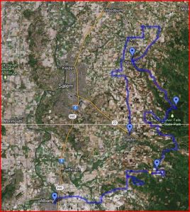
An overview of the route is to the right; total mileage: about 125 miles.
 When I started planning the route, my goal was to find at least one road that at least one person in the club hadn’t been on before. So, I spent some QT with Google Maps plotting. I can heartily attest to the value of doing a check ride–far enough in advance that you can make route changes as necessary.
GPS thinks that you can get from Rodgers Mountain Loop over to Lulay. They probably were connected at some point … by a logging road no longer in use. Fortunately, that was the only bobble in planning. I decided to leave the loop as part of the route, because it really is a gorgeous, rolling 7.4 miles.
Turns out Dave had never been on this road before. WOO HOO! Success ![]()
The navigator (that would be me) went straight on Bilyeu Creek when I had intended to turn left. However, it turned out to be a GREAT mistake, because I found a road John hadn’t been on, and more importantly, a gorgeous pink Cadillac in a driveway. Finding a road John Turner hasn’t been on is the coup de gras. (Yay, me!)

At the first rest stop (Our Lady of Lourdes church), Duane shared what he knew of the history. And I popped open the trailer and rolled out the Pink Tea (Raspberry Snapple) and a few other pinkish snacks. Apparently this raises the bar a little higher for the next Ride Masters. (And now I have to figure out how to top that if they let me be Ride Master again.)
From the first stop we rambled to a turn-out in the Silver Creek Falls park. (um, note to self: parking, Memorial Day weekend, not so great) And from there to Silverton for lunch.
After lunch, we headed north up to Marquam, then west to Mt. Angel–via the scenic route, of course. We meandered south towards Stayton. I confess the navigator goofed again, but I think I covered pretty well, and no one will ever know.
It was a great route, if I say it myself. Given another 5 degrees or so of temperature–if bullying the weather into cooperation is possible–and it would have been a perfect day all around.
